I really just want to revisit this post done in September 2012 because this story (and pictures) are special to me. But, I also added some new points!
I haven't had the chance of "flying" over Zamboanga City again, but when I saw the really beautiful aerial pictures of my friend, Sixto Kwan (Six2K), I asked him if I can use his photos in this blog!
I haven't had the chance of "flying" over Zamboanga City again, but when I saw the really beautiful aerial pictures of my friend, Sixto Kwan (Six2K), I asked him if I can use his photos in this blog!
I'd like to compare Zamboanga City, before (circa 2005) and after (circa 2012) but of course, the angulations would be different considering the different photographers and more so, different chopper pilots!!!
I actually want to share the changes in Zamboanga City topography rather than compare picture quality!
Here goes:
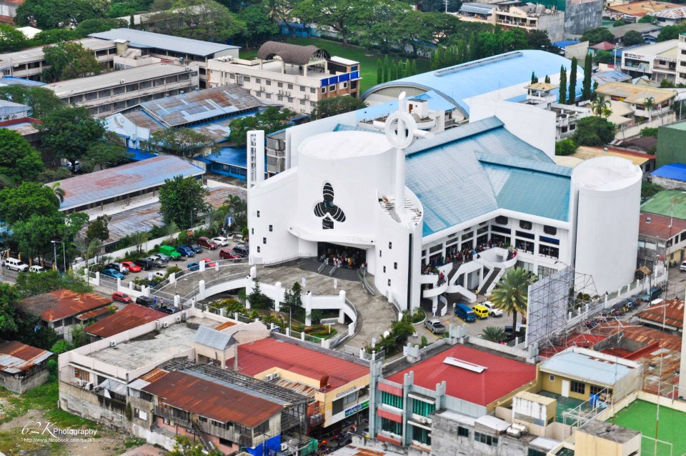
Metropolitan Cathedral of the Immaculate Conception (MCIC)
2005
 |
| Metropolitan Cathedral of the Immaculate Conception (MCIC) in 2005 |
2012
 |
| Metropolitan Cathedral of the Immaculate Conception (MCIC) in 2012 |
The two pictures are shown in different angulations: the 2005 picture viewing Mindpro mall (white box-like building on our left side) while the 2012 picture viewing Ateneo De Zamboanga University.
Can't really figure out if there are obvious new buildings in the Pueblo area. I am not expecting any big change, though, since this was a congested area in the first place.
Can't really figure out if there are obvious new buildings in the Pueblo area. I am not expecting any big change, though, since this was a congested area in the first place.
What I can say was that the Immaculate Conception Cathedral was much newer then...and of course, the new belfry, too, with the Carillon bells!
But, the rooftops across the MCIC look better in 2012!
But, the rooftops across the MCIC look better in 2012!
Fort Pilar
2005
 |
| Fort Pilar in 2005 |
2012
 |
| Fort Pilar in 2012 |
I guess the position of the photos are similar.
So much has changed since Paseo Del Mar and Plaza Del Pilar did not yet exist around Fort Pilar in 2005.
Inside Fort Pilar, the green shrubs are now taller.
In Fort Pilar, the fountain and the Carillon bells are now seen. The plants are now taller and more green.
Across the Fort Pilar Shrine and across the National Museum, there are very many adobe-roofed stalls lining the area.
And on the right side (our right) of Fort Pilar is another set of adobe-roofed stalls, the Plaza Del Pilar which did not exist then.
It is nice to see the huge acacia trees still in the area of the the plaza Del Pilar. since they add beautiful rustic and vintage character to the area.
Also, I can identify the new Bangko Sentral building in Zamboanga City, in our right upper hand corner near Lantaka Hotel, and across Paseo Del Mar!
2005
|
| Fort Pilar in 2005 |
 |
| circa 2005: view of back part of Fort Pilar (Real Fuerza de Nuestra Señora del Pilar de Zaragoza (Royal Fort of Our Lady of the Pillar of Zaragoza) in honor of the patron virgin of Spain, Our Lady of the Pillar. |
 |
| there are now many structures within the Paseo Del Mar but the grandiose dancing and musical fountain, but still maintained a huge park ground to stroll around! |
We didn't focus the picture in the Paseo Del Mar area before because it was just a vacant lot.
Paseo Del Mar now has a beautiful musical and dancing fountain as the main attraction and of course, all the food stalls and restaurants which has enlivened the place. You'll now find Tony's Papaitan and Kape Zambo in the new building near the fountain aside from the line of restaurants in the original side like Barcode, Mano-Mano, Alavar's and many others.
All kinds of people come over = families, couples, friends, get togethers, meet ups and of course, where we bring our visitors and guests from other places.
Nuñez Extension
(now Mayor Vitaliano Agan Avenue)
(now Mayor Vitaliano Agan Avenue)
2005
 |
| viewing Ciudad Medical Zamboanga: Nunez Ext. directed to Ateneo De Zamboanga University |
 |
| viewing Ciudad Medical Zamboanga in Nunez Ext. with "lakeside view" otherwise known as kangkong fields. |
2012
 |
| viewing Ciudad Medical Zamboanga with Nunez Ext. directed to Camins St. .. CMZ can still have a mountain or "lakeside" view with the kangkong field still present close to it! This is so because Nunez Extension was opened in the early 2000s |
 |
| viewing Ciudad Medical Zamboanga with Nunez Ext. directed to Camins St. ... see far beyond to the mountains and see Mt. Pulong Bato and Muruk on our right hand side! By the way, Nunez Extension is now called Mayor Vitaliano Agan Avenue!!! |
Nunez Extension was an almost empty street in 2005 with few establishments other than Ciudad Medical Zamboanga.
By the way, did you know that Nunez Extension is now called Mayor Vitaliano Agan Avenue?
Yes, it is!
Here is the link:http://www.zamboanga.gov.ph/files/2009/ORD/reg353.pdf
The road was named after him because it was in his term as Mayor (1988 to 1998) that they proposed the "Opening of the Nunez Extension Road".
That is why even if the Mayor Agan Avenue (Nunez Extension) is in the center of the City, it is still a relatively new road which opened in the early 2000s.
Well, Zamboanga City has grown to be a more beautiful, slightly urban center.
By the way, did you know that Nunez Extension is now called Mayor Vitaliano Agan Avenue?
Yes, it is!
Here is the link:http://www.zamboanga.gov.ph/files/2009/ORD/reg353.pdf
| 353 | AN ORDINANCE "NAMING THE NUÑEZ EXTENSION ROAD" AS "MAYOR VITALIANO D. AGAN AVENUE" | Enacted: 19 Aug 2009 Approved: 26 Aug 2009 |
The road was named after him because it was in his term as Mayor (1988 to 1998) that they proposed the "Opening of the Nunez Extension Road".
That is why even if the Mayor Agan Avenue (Nunez Extension) is in the center of the City, it is still a relatively new road which opened in the early 2000s.
Well, Zamboanga City has grown to be a more beautiful, slightly urban center.
P.S.
Thanks Six2K for the new pictures (with watermark).
The older pictures were taken by me in 2005
Ang ganda naman...looks like a very clean city :-)
ReplyDeleteLovely arial view. My city is full of skyscrapers and won't be able to see the mountains like you did on a ride.
ReplyDeleteI'm glad you reposted this. Nice to see the changes. i only ever visited Zamboanga City once and I don't really remember going around so much. I would love to visit again.
ReplyDeleteThese are good takes for comparison. Zamboanga City is very nice and it looks clean too!
ReplyDeleteI love the backdrop! A far cry from where I live. Is your airport wheelchair friendly?
ReplyDeleteI like these before and after photos. Looks like the development hasnt affected the cleanliness of the place yet.
ReplyDeleteit's nice to have some old pictures of places, you can actually compare and see the development of the place.
ReplyDeleteI love that there are many green patches which show that the people there preserve nature. :-)
ReplyDeleteGreat shots! I think this is one of my regrets - not going to Zamboanga City. I am a Mindanaoan, too, (surprise!) and have lived in Iligan all my life. But now am based here in Metro Manila. But as a member of the Jaycees, we used to travel a lot. I hope one day, I could go and visit. :)
ReplyDeleteEven with the years difference, one thing I noticed that's still preserved are the greens and your mountains. That's a good thing. :-)
ReplyDeleteI didn't know until now that Nunez Ext. is already named after our former Mayor Agan. :)
ReplyDeleteI been to Paseo del Mar 2 years ago. I think there are more improvements now. I hope to visit again maybe this year. hopefully. :)
ReplyDeletei am grateful to see the changes, parang narating ko rin ang place niyo hahaha
ReplyDeleteWow..it's good that you still keep the photos of the place before and after. At least, you could keep records of it's progress and developments. Nice photos! :)
ReplyDeleteBeautiful photos. I have not tried flying on a chopper. I might get scared.
ReplyDeleteIt's wonderful to be able to have pictures to see how a place has developed through the years. I should start taking more landscape pictures so my kids can someday see how Manila has changed.
ReplyDeleteall I can say is the place is growing and developed over the years.. you're lucky to have the before and recent photos..
ReplyDeleteNice city, and the first pic, the cathedral has been well-maintained! What lens are you using in those aerial shots?
ReplyDeleteZamboanga is a nice, fine place eh. Great shots and love how it changed, for the good.
ReplyDeleteAt least the changes don't look drastic in the photos... ;-)Interesting!
ReplyDeleteEliz bc blogger - http://positivekismet.blogspot.com/ -
For 7 years, there are already many changes in your place. This only means that your city is keep on developing.
ReplyDeletecool aerial pics!
ReplyDeleteAng ganda! Though there are changes na, still maganda pa din. I am hoping to visit Zamboanga soon.
ReplyDeleteMommy Maye
www.momaye.com
Urban planning for Zamboanga has not done very good. The city planning office has been in existence long time ago but has not shown how plans are on the drawing board in anticipating for the future expansion projects for the city. Whereby, from the aerial photo views as we see, there are only 3 main arteries that comes from downtown going north; north-east, Canelar road; the Vit Agan Road or Ave.; the Old Veterans Avenue...as you see there is no new road openings that traverse from East to West/ West to East from that area. So thereby, creating a huge amount of traffic during rush hours or even on regular hours of the day. If the city are planning to do it now, the city will spend billions already to clear up residential and commercial structures that already sprouted. It could have been done long time ago when it was just plain rice fields all around Veterans Ave, and Vit Agan Rd. Sta. Maria to Tumaga has only one road to traverse, in-between those area could have been made possible long time ago to create new roads, but nothing has been done and now residential and commercial structures are already all over. Does planning and creating roads has to be done the hard ways?
ReplyDeleteInteresting and really experiential insight! Definitely, the traffic is bothering the residents now and it is a pain to clear up existing structures.I hope our city officials come across your comment.
DeleteWhen I think of Zamboanga City, I feel Nostalgia all the time huhu.
ReplyDelete